OOI Mapping Cruise 2008
Back to the Volcanic Axis of the Juan de Fuca Ridge
Thu, 31 Jul 2008 5:21 PM PDT
Sentry Goes to the Bottom
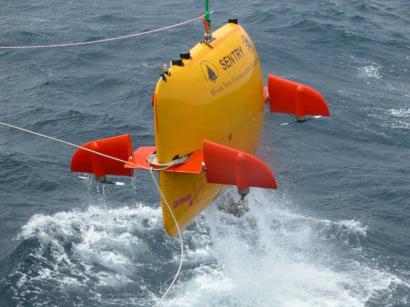
After a day of transiting from Newport and navigating equipment complexities while dodging small storms, we opened the day armed with a new altimeter on TowCam and a new lease on the software issues in the "cerebellum" of Sentry. It is late morning, and Dana Yoerger and James Kinsey are fairly bouncing as they go through the final checks on the system before launching the AUV over the side of the ship. Both men are operating on two or three hours of sleep over a 26-hour period during which they struggled to diagnose and solve the problems that cropped up yesterday. Captain Phil Smith and First Mate John Wilson, working with Andy Billings of WHOI, delivered a smooth launch of the now well-decorated AUV (see figure). The gusty weather of yesterday has flattened out to a very workable condition on the deck.
Rough Terrain, Rough Weather
Dana laid out a plan that has Sentry starting its initial survey of Axial Volcano in the flat and comfortable sediments of Thompson Basin. Then the AUV will climb steadily up the steep slopes mapping the volcanically dominated terrain of the lower portion of Axial.
Our most enduring question is how well the observatory cable will fare in this environment that resembles the lower slopes of the Mauna Loa-Kilauea system in Hawaii. Early pioneers, like Fred Duennebier of the University of Hawaii, have laid cables offshore on the Big Island and have had them compromised by the harsh conditions and rough terrain encountered on the underwater flanks of Kilauea. We hope to have learned by Fred’s experiences.
TowCam Follows Sentry: The Machine Dance Begins Again
Tracking the AUV with the transponder net and a sensitive receiver on the bottom of the ship, the Sentry group watches like hawks as Sentry makes its “first turn” onto the survey grid laid out with great precision by Dana. Satisfied that it is behaving as programmed, he passes the control of the ship over to use by the TowCam group now lead by Eric Horgan. The volunteer team assembled by Eric now consists of Jennie Mowatt, Dax Soule, Cody Young, Janet Beckmann, and our newcomer, Cara Mathison. This group always attracts attention of others as they shepherd the rugged camera sled to the seafloor and begin the precision flying up the slope of the volcano.
A Thought Experiment
Imagine riding in a high-altitude hot-air balloon dangling a Nikon Camera on the end of a mile and a half rope. Then imagine flying through the Rocky Mountains and trying to take pictures of the meadows, the trees, and the rocks from a height of 4 meters (12 feet) without crashing and destroying the camera.
This is a rough analogue to the challenges that TowCam faces as it moves over the deep seafloor. The system that Dan Fornari designed and built, and that Eric and the team are now operating, is a testament to the integration of practical experience and design elegance. Obviously the two altimeters are key elements that enable precise control of the ship (the balloon) to avoid disaster. Thanks to high-precision GPS and computer-driven controls, the nearly 93-meter ship can be controlled to within less than a meter.
Robots Working Together
All afternoon and evening both systems continued their simultaneous, and very different approaches to collecting information about the rugged, deep flank of Axial Volcano. Emulating marine mammals, Sentry is using sonar to “see” through the water and map the shape and depth of the deep seafloor. TowCam is using the more human-familiar sensing capability of visual mapping by taking high-resolution digital snapshots of the bottom every 15 seconds for hours as the ship moves it slowly along a preset path. As a result, all attention of the TowCam group is focused on keeping the camera at the right altitude above the seafloor to ensure proper range and lighting for the photography.
The complementariness of the simultaneous and spatially coincident sonar and visual approaches is a very powerful way to assess the conditions that will be experienced in our attempts to lay cable and place nodes into the fabric of the seafloor to ensure decades of uninterrupted service from the Regional Cable Obervatory.
"Seeing" and "Hearing" the Seafloor
One reason that we and other mammals use sonar in the ocean to determine what the undersea environment “looks” like is because seawater does not transmit light very well. A very bright light barely offers any usable illumination at a distance of 20 meters. In fact, bright red objects, like some tube worms or brightly colored crabs, lose their distinctive red color at distances of about two meters because red wavelengths of visible light are so strongly absorbed. As a consequence, an object that is bright red, appears nearly black at 3 meters distance if the light is not bright enough.
It is difficult to operate in the deep ocean where no sunlight ever penetrates; we must bring with us any light we use. Furthermore, to produce a decent sonar map, the AUV has to "fly" fairly high as that it "maps out" the terrain below. This height may be as much as 50 to 100 meters above the bottom. So it is not possible for the AUV to literally "see" the seafloor visibly from that elevation with any type of normal camera/lighting system. That is why we use the two systems: one designed to ‘see’ the seafloor with its own lamp and a close approach of 4 to 5 meters (TowCam), and the other designed to "hear" the seafloor from a much greater distance of, say 80 meters elevation above the bottom (Sentry).
After the cruise we will merge these visual and acoustic data sets and have the best of two worlds: detailed shapes of the volcanic flanks and visual confirmation of what the detailed rock types, and sediment types (and animal types…) are in the same areas of interest.
A Good Day
As the day draws to a close, Sentry is still operating deep on the lower slope of Axial where it is mapping the steep cliffs that bound Thompson Basin. It will not return to the ship until 0900h on the morning of August 1. TowCam returns from its deep-sea photo-documentation sojourn slightly later than midnight today (actually very early morning on August 1). After a day visiting Newport and another day of transiting and dealing with equipment troubles, we have had a fairly full day of productivity during which both systems worked well and we even picked up a little EM 300 data on the side.